When you think of an ISRO mission "delivering results," your mind probably jumps to a Mars orbiter or a Chandrayaan landing. This week the news comes from a quieter, harder-working part of the space programme: a satellite quietly orbiting overhead, watching the ground move.
NISAR - the NASA-ISRO Synthetic Aperture Radar satellite that launched from Satish Dhawan Space Centre, Sriharikota, in July 2025 - has just published one of its first major Earth-observation results. It mapped how fast Mexico City is sinking. The answer: by a few centimetres every single month, in patches across the metropolitan area. And the technique it used to do it is exactly what India is going to need at home.
What NISAR actually saw
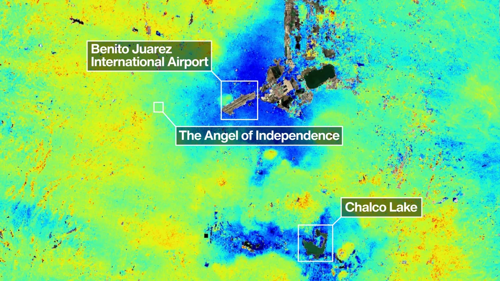
The map at the top of this story is built from radar measurements NISAR took of the Mexico City basin between 25 October 2025 and 17 January 2026. The dark blue patches are areas that subsided by more than 2 centimetres per month during that window. The yellow and red areas are mostly residual noise - expected to clean up as more data comes in.
Three landmarks are visible in the frame:
- Benito Juarez International Airport - Mexico City's main airport, sitting in one of the worst-subsiding zones.
- The Angel of Independence - a 36-metre-tall monument built in 1910 to mark 100 years of Mexican independence. Workers have had to add 14 extra steps to its base over the decades because the ground around it kept dropping. It's effectively a slow-motion measuring stick for the entire city.
- Chalco Lake - visible as the dark green oblong in the southeast, in another fast-subsiding pocket.
Mexico City is home to about 20 million people and is built directly on top of an ancient lakebed and a heavily-pumped aquifer. Decades of groundwater extraction plus the weight of construction have been compacting that lakebed since 1925. In the worst years of the 1990s and 2000s, parts of the city were dropping by 35 centimetres per year - fast enough to crack roads, snap water mains, and warp the Metro tracks of one of the largest rapid-transit systems in the Americas.
Why this is a big deal for an Indian satellite
Many Earth-observing satellites can take a picture of Mexico City. Very few can tell you how the ground underneath the city moved by two centimetres last month - through cloud cover, at night, in any weather.
That's the trick NISAR pulls off. It uses synthetic aperture radar (SAR) at two wavelengths:
- L-band SAR, built and supplied by NASA's Jet Propulsion Laboratory in California.
- S-band SAR, built and supplied by ISRO in India.
The Indian-built S-band radar and the spacecraft bus that carries both instruments are doing a job no other civilian satellite in orbit can do - they're the first satellite ever to carry two SAR instruments at different wavelengths, working together. NISAR also carries the largest radar antenna reflector NASA has ever launched - a drum-shaped dish 12 metres (39 feet) across that unfolds in orbit.
The L-band wavelength is the part that makes the Mexico City result possible. Long wavelengths see through clouds and dense vegetation in ways that shorter-wavelength radars and optical cameras can't. As Craig Ferguson, deputy project manager at NASA Headquarters, told JPL, this is exactly what's needed for "more challenging and densely vegetated regions such as coastal communities where they may have the compounding effects of both land subsidence and sea level rise."
Read that quote again. He's talking about places like Kolkata, the Sundarbans, Chennai, Mumbai's reclaimed wards, the Konkan coast - coastal Indian cities that are sinking and dealing with rising seas at the same time.
How NISAR works, in plain English
NISAR doesn't take photographs. It pings the ground with radar pulses on every overhead pass - twice every 12 days, globally - and then compares the return signals from one pass to the next. If the ground moved between two passes, even by a few millimetres, the phase of the radar echo shifts in a measurable way. Stack enough passes and you can measure motion at the centimetre, sometimes millimetre scale.
The same technique that just caught Mexico City sinking can track:
- Glaciers sliding in the Himalayas
- Subsidence in Indian cities built on alluvial soil or over-pumped aquifers (Delhi-NCR, Bengaluru, Joshimath have all seen serious cases)
- Dam and embankment deformation before a failure
- Crop growth across entire states, week by week
- Earthquake fault movement before and after a quake
That's the power of an L-band/S-band SAR observatory - one satellite, an enormous list of jobs.
What changes for India next
NISAR's data is free and open to any researcher, government department, or university - including in India. ISRO and NASA share the satellite's full output. That means agencies like the Central Ground Water Board, the National Remote Sensing Centre (NRSC) in Hyderabad, and state disaster-management authorities can now ask questions they couldn't reliably ask before:
- Which neighbourhoods of Bengaluru and Delhi are sinking the fastest, and how does that line up with groundwater extraction?
- How is the Ganga delta moving, year on year?
- Which Himalayan slopes are creeping in the months before a Joshimath-style event?
- Are coastal embankments in West Bengal and Odisha quietly losing height before the next cyclone season?
David Bekaert, a NISAR science team member, told JPL that the Mexico City image is "just the beginning" - a dry run for an "influx of new discoveries from all over the world, given the unique sensing capabilities of NISAR and its consistent global coverage."
For India, the most consequential discoveries will be the ones that show up in our own backyard. NISAR is the first time we've had this kind of global ground-motion truth-meter in orbit, and it was built - half of it, including the spacecraft itself - by ISRO.
If you'd like to follow what NISAR maps next as the data rolls in, our spaceflight section is the place we'll be tracking it.